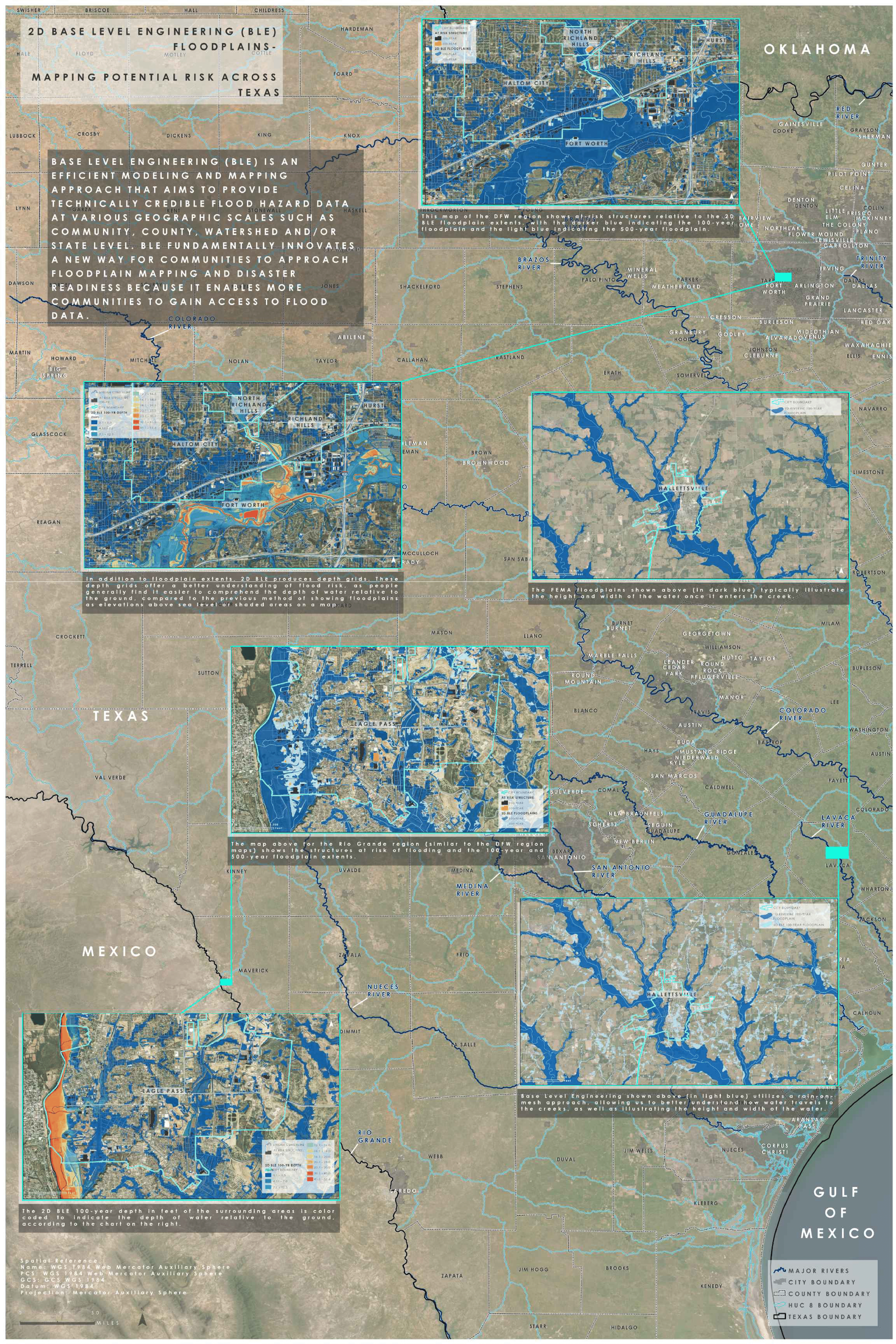
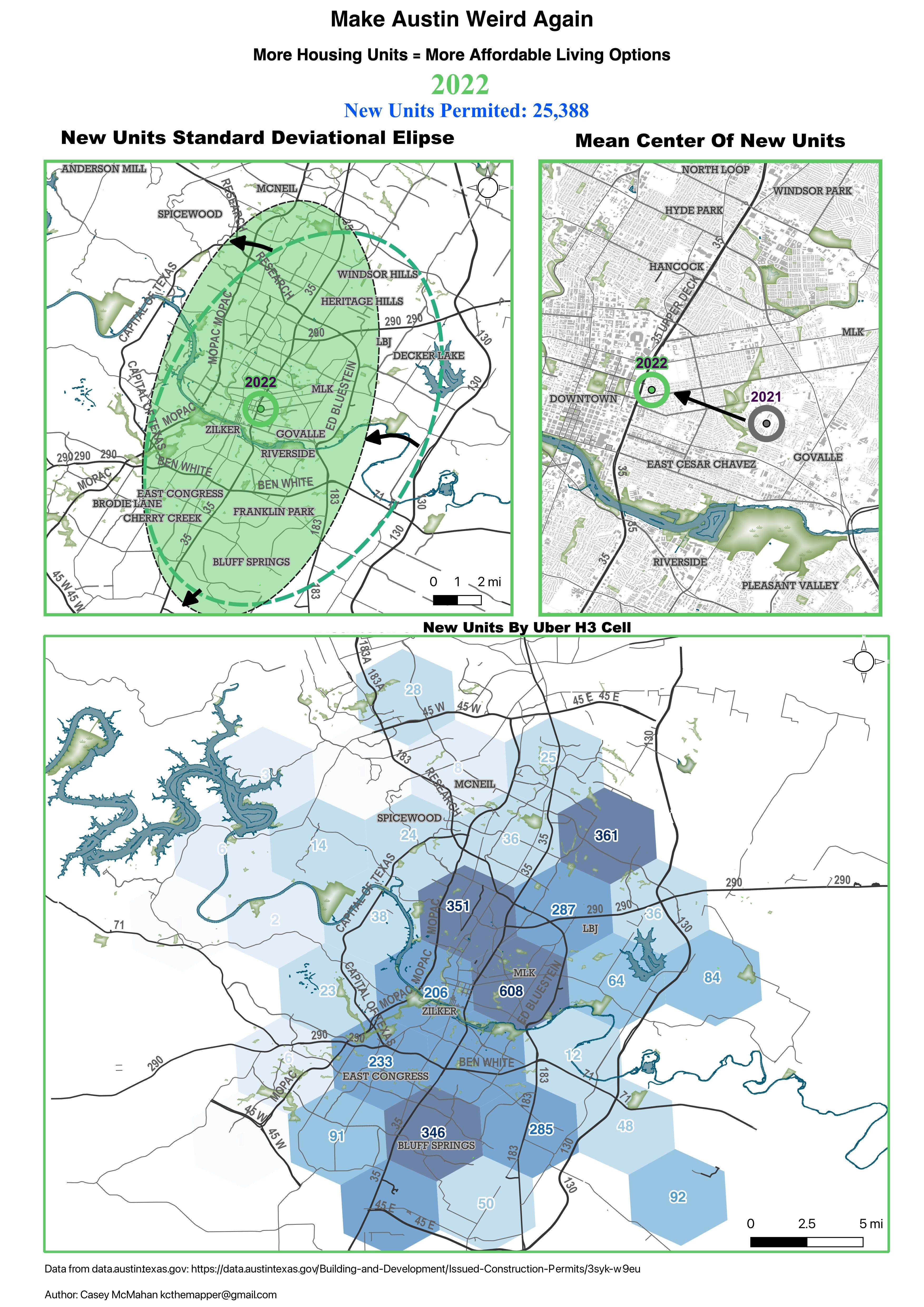
ATX GIS DAY
November 13, 2023

About

Get the details on this year's in-person GIS Day!

When?

November 13, 2023

Give us Your FEEDBACK!

What's GIS DAY?

GIS Day is an international forum for geographic information system (GIS) users to share their knowledge and applications of GIS technology. GIS day provides an opportunity for students of all ages, professionals, businesses and the public to discuss the impact GIS has on our daily lives.


2023 Agenda


EXPERIENCE THE BUILD

2023 is all about Building your Network,

Building your Career,

& Building the right GIS for your needs!

Get Zoom links to our hybrid events on TxGIS Day

  • BUILD YOUR KNOWLEDGE

    WORKSHOPS

    • 9-10 AM Back to Basics – SQL Database Objects
      Lee Kinser, City of Austin
    • 10-11 AM Field Maps: a hands-on demonstration of Esri's field data collection application
      David Gimnich, City of Austin Transportation Public Works, Data and Technology Services
    • 12-1 PM Marrying FME & GIS
      Stephanie Long, Austin Community College & Mike Long
  • BUILD YOUR NETWORK

    HEADSHOTS 12-1 PM with Open Networking & Exhibitor Booths

    Sign up for CAREER CUPID Virtual Speed Mentoring 11/14

    CONFIRMED MENTORS:
    • RoxAnne Parker
      Application Analyst, City of Austin
    • David Gimnich
      IT Business Analyst Sr, City of Austin
    • Franzi Davis
      Senior Consultant, TLC Engineering Solutions
    • Jacquie Hrncir
      IT Manager, City of Austin
    • Jared Ware
      Director, Railroad Commission of Texas (RRC)
    • Jacquelyn "Jacq" Bilbro
      Director of Production, Enco Consulting, Inc
    • Chris Bardash
      Mapping Branch Manager, TxDOT
    • Diana Martin
      IT Supervisor Sr, City of Austin


    Click Here for Mentor Biographies
  • BUILD YOUR CAREER & THE RIGHT GIS

    PRESENTATIONS


    Get Zoom links to our hybrid events on TxGIS Day

    • 11 AM Opening Remarks & KEYNOTE:
      Web AppBuilder to Experience Builder
      Laura Chapa, Esri
    • 11:40 AM Digital Twins for Asset Management
      Courtney Malott, Fugro
    • 1 PM Automation of Bike Facilities Assessment by Python in ArcGIS Pro
      Romina Tafazzoli, City of Austin Dept. of Planning
    • 1:20 PM Bicycle Network Analyzer
      Rémy Greinhofer & Luis Alvergue, PeopleForBikes
    • 1:40 PM GIS & AI
      Thomas Montgomery, City of Austin
    • 2:20 PM ArcGIS Indoors – The DIY Method
      Deborah Massaro, ACC
    • 2:40 PM Building Remote Sensing Workflows with Google Earth Engine
      Matt Hiland, Sanborn
    • 3 PM Lightning Talks with UT Austin, ACC, City of Austin, CenTex GIS + more
    • 3:20 PM MAP CONTEST & Closing
      Honoring TxGIS Hero Travis Acklin, City of Seguin

      Give us Your FEEDBACK!

  • SOCIAL MAPPY HOUR

  • Come
    Join us on
    GIS Day!

Map Gallery

In 2023, all submissions will be displayed in an online virtual map gallery.
If you wish to have your map displayed physically on GIS Day, contact atxgisday@gmail.com.

Deadline: November 10, 2023 11:59 PM Central Time

Static Map (image or pdf file) or Dynamic Map (includes Web maps, Dashboards, StoryMaps, etc) should be submitted electronically to a cloud service (Google Drive, Dropbox, Box, etc.) by the deadline.
Submit the title & shareable link to the static map or dynamic map by clicking the submit button below:

SUBMIT A MAP

Erin McManus

Heather Ketten

Weatherly Sawyer

Weatherly Sawyer

Competition

The ATX GIS Day static map and dynamic map competition is open to all students and professionals.
For any questions regarding the map competition details, please email atxgisday@gmail.com.

Competition Guidelines & Judging Criteria

If some of the Competition Guidelines & Judging Criteria don’t apply to your submission, don’t be discouraged. Please submit your work! These guidelines are set for you to present your best work and for the judges to have a framework to fairly assess each submission equally.

  • Any Cartographic, GIS and/or Remote Sensing work will be accepted.
  • Submission may be of ongoing or completed work.
  • Submissions may be for individual or team work.
  • You may submit unlimited entries per person.
  • A map is not required on your submission, but you are submitting to a GIS Day Competition, so...
  • Submissions should include introduction, objectives, approach, results, discussion, and conclusions (or their equivalents).
  • Submissions must include a clear statement on the Map Geodetics. This should identify the Projected CRS, Datum, etc.
  • Submissions must clearly state map scale.
  • Submissions must make effective use of Geographic Information - appropriate use and portrayal of spatial data.
  • Submissions must demonstrate accuracy - grammar, punctuation, spelling, text font, text size, figures, tables in English (or with translations if showcasing other languages).
  • Submissions must use effective design/layout - logical organization and visual flow of text and graphics.
  • Submissions must have visual appeal - color coordination, geometry, accents, highlights, use of symbology.
  • Submissions should demonstrate effective communication - understandable and concise.
  • Submissions must be in pdf or jpeg format - pdf format is PREFERRED.
  • Submissions may not exceed 10MB.
  • Winners do not have to be present to win but maintain the responsibility of collecting any prizes that are won in the contest.
  • Winners will be responsible for any government taxes.
  • Only one (1) prize can be awarded per map entry (even if a map has multiple authors, only one prize is awarded).

Winners will be announced
on Monday, November 13
at the ATX GIS Day Closing session.

PREVIOUS 2022 AGENDA


  • Room 1526

    FME 101 Workshop
    • 9:30AM - 11:00AM CST
  • Lounge and Zoom

    Career Cupid - Speed Mentoring Event
    • 11:00AM - 12:00PM CST

  • Auditorium

    • 12:20PM - 3:30PM Presentations
      • Safe Routes to School Program
      • Facilities & Construction GIS Initiative @ ACC
      • Communicating Wildfire Risk Through GIS: The Austin-Area Wildfire Hub
      • Short Examples of GIS Programming with the Python Arcpy Library
      • QGIS
      • Networking and Volunteering and Being Present
      • Learning GIS in this Day and Keeping up with Technology
    • 3:00PM - 3:30PM GIS Hero Spotlight
      • Felicia Retiz
    • 3:30PM Closing
      • Announce Map Winner

  • Exhibit Hall

    • 12:00PM - 3:30PM Tech Petting Zoo
      • Welcome table
      • Austin Parks and Recreation
      • EcoRise
      • TNRIS
      • Bad Elf
      • City of Austin Watershed Protection Department
      • City of Austin Enterprise Geospatial Data Services
      • AllTerra Central
      • Sanborn + AppGeo
      • TeachMeGIS
  • Social

    • 4:30PM-7:00PM
      • Easy Tiger - The Linc

Participate

Get deep into the fun and activities by participating!

Showcase

Present a project at GIS Day
Maps
Apps
Workshops
Prepared Presentations
Submit to present HERE!

Not taking Sponsorship this 2023 - FREE for everyone

Become an ATX GIS DAY sponsor and extend your recognition, reach your target market and support GIS Day outreach and education efforts to area schools.

Volunteers

ATX GIS DAY would not be possible without the help of volunteers! Opportunities include planning, moderating, graphic design, and leading K-12 activities.
Sign up HERE to volunteer!

Our Partners

A big thanks to our wonderful partners who make this event possible!


Contact Us

Got questions or want to help? Please feel free to drop us a message!